MAP BALLOON
|
Local Government Help > Documentation > Map Balloon
|
The Map Balloon Opens to Display Selected Information when a Layer Feature is
Clicked on the Map
|
| Commands |
Provides the ability to access additional functionality for the identified feature. Click the commands button to open the command balloon.
|
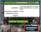
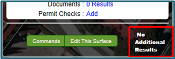
| More Results |
Displays at the bottom right corner of each window letting you know if additional data is available at your map location. A number displays when there are two or more identifiable (or active) layers at your map-click, or search location.
Click the Results down arrow to open a menu that lists the additional data layers. Click the layer you'd like see summary information for.
In the example to the right, CustomAddress and ParcelDetail are active layers. When there is only one active layer at your location, the window displays No Additional Results.
|
|
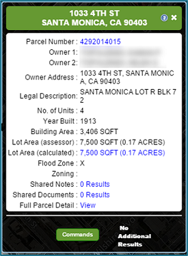
| Map Balloon |
Displays comprehensive detail on the selected parcel, such as Owner Name and Address, Legal Description, Building and Lot Area and Hazards. The map balloon is movable by selecting the header of the balloon and moving its location for individual preferences within the application interface.
Click on the interactive links in the balloons to uncover deeper information. Hyperlinks can take you directly to the Property Details or Full Property Detail report. You can also access your linked documents and notes, and even turn parcel measurements on by clicking on Lot Area.
|
|
| Tell us what you think |
Feedback
|
|