|
Local Government Help > Documentation > Boundary Constraint Searches
|
|
Boundary constraint searches are a powerful tool that enables you to easily constrain or limit your search to a specific desired boundary area, for example a city boundary or a zip code boundary.
|
Boundary Searches Overview
|
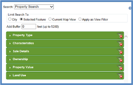
Boundary data sets in GovClarity™ can easily be used as a search constraint. By selecting one of the Limit Search To options on the search form, you can quickly target your searches.
- City Boundary: Lets you limit any search criteria selected to properties within the city boundary. (Note: this is the default setting)
- Selected Feature: Lets you limit any search criteria selected to information bounded by any feature on the map such as a line buffer, inspection area, or zip code (Note: this option will show as default if a feature is selected on the map).
- Map View: Lets you limit any search results to selected to information contained in the current map view.
- Add Buffer: Lets you apply a buffer to any selected boundary or line.
You can also choose to run your criteria as a filter by selecting the "Apply as View Filter" radio button.
|
Limiting Searches to Geographic Constraints
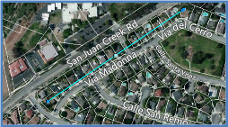
- Identify an existing boundary on the map by clicking on it (image will show squares at vertices) or draw a new polygon, line or circle using the Drawing Tools. For more information about using the Drawing Tools, refer to Related Documents below.
- Click the Search icon
 to launch the Search Forms Window to launch the Search Forms Window
- Select the type of search you would like to conduct from the Search pick-list at the top of the window.
- Select a "Limit Search To" option or choose Apply as View Filter
- If you'd like to apply a buffer to any of the selected search boundaries, you can do so by inputting the buffer distance in the Add Buffer box.
- Enter search criteria by expanding the search categories or simply click OK to return all results within your boundary.
- Your search results will automatically be added to a list below the map and the results within the map view will be numbered in correspondence with the sort order of the search results list.
|
|
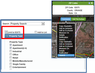
Limiting the Search to the Zip Code Boundary
- Navigate to the zip code that will be used to limit your search results.
- Click on the zip code boundary
- When the information balloon appears for the Zip Code layer, click Commands and choose Search.
- The Search window will open and you then check the box Limit to [Zip Code] and then complete your search. The zip code for the boundary you selected will display in the Limit to field
|
|
Related Information
|