
|

|
GOVCLARITY™ SUMMER RELEASE
| Local Government Help > What's New > GovClarity Summer Release | |
|
Digital Map Products is excited to announce the release of a new version of GovClarity™. The latest version includes several new features that make it even easier to integrate and manage your agency's key data sets, publish information to residents via online maps, and engage constituents through their mobile devices. New in GovClarity™ is direct integration with ArcGIS Server and ArcGIS Online, auto-authenticated log-on, simplified identify functionality, expanded Address Management options, the ability to embed CommunityView™ directly in your website pages, our new Connect constituent mobile app and more... Keep reading to learn more about these great new features and how they can help your agency extend the reach and value of your existing data and systems, streamline department workflows, engage residents, and bring user-friendly mapping tools to your entire organization. |
Data Integration | |
|
Because having your key department data sets easily accessible by all your staff is so important to the effectiveness of your agency, we've expanded our GovClarity™ integration capabilities to include ArcGIS Server and ArcGIS Online. We've also created some helpful example integrations showing how to simple it is to link your permit and EDMS (Electronic Document Management System) data to parcels in GovClarity™. |
|
|
With integration to ArcGIS Server and ArcGIS Online, you can publish your GIS layers to GovClarity™ to maximize your GIS investment and significantly widen the distribution of your GIS data, all without added training or licensing costs. Further, our open APIs let you link your specialized systems to GovClarity™ so users can access data such as permit information or documents from your EDMS in a single click of a parcel. GovClarity™ has several options to help you increase the access, usefulness, accuracy and currency of your agency data for both your staff and the public. Whether through our data loaders, map editing tools, open APIs, or data synchronization processes, you now have the tools to maximize the value of your data. |
|
|
Visit the links below to learn more about these new features: ArcGIS Integration | Permit Data Integration | EDMS Integration |
|
Usability | |
|
Now in GovClarity™, you can streamline your users' login process and make forgotten usernames and passwords a thing of the past with Auto-Authentication. The Auto-authentication option lets you use your agency's network login credentials to validate access to GovClarity™ so users don't have to log into GovClarity™ separately. |
|
|
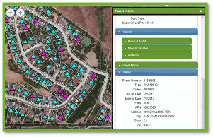
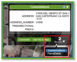
Another usability enhancement is our new identify. GovClarity™ simplifies layer identification and returns links to each layer currently displayed and identifiable in the summary balloon. When only a single layer is identifiable at a particular location, the link will say ''no additional results.'' Also, users can now share their content with individual users, groups, or everyone in their GovClarity™ account. Located under the Advanced Menu, you can share layers and styles, map compositions and saved results lists. Last, but not least, we heard your requests, and the Summary Window that appears when you search to or identify a feature is movable. You can position the window anywhere on the map screen simply by clicking, holding, and dragging to your desired location. |
|
|
Visit the links below to learn more about these new features: Auto Log-On | Multi-Layer Identify | Content Sharing |
|
Address Management | |
|
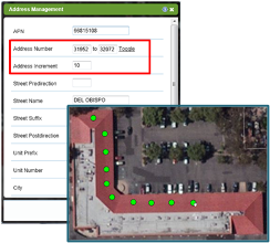
Address management is now more robust with the additional address placement options. You still have the ability to place a single address, but now you can also place multiple addresses in a single action. Use the ''add repeating addresses'' command to add multiple address points that auto-increment within a given address range. Use the ''add group address'' command to add a single point representing a specified range of addresses. We've also enhanced the Notifications feature in GovClarity™ to use your custom addresses. If any of your custom addresses fall within a notification area, those custom addresses will be included in the notification contact list. |
|
|
Visit the links below to learn more about these new features: Address Management Workflow | Notification Workflow |
|
Constituent Engagement | |
|
The latest version of GovClarity™ includes even more ways you can reach out to constituents and engage them in conversations to improve your community. Now, you can stay connected to your residents through their mobile devices with our CommunityView™ Connect app. CommunityView™ Connect is the mobile connection to your city. The public can use Connect to report an issue, such as graffiti or a pothole, stay current on your city's latest news, learn about upcoming city events, or even look up city information. Connect is where the conversation begins between your city and the public. Additionally, you now have the option of embedding CommunityView™ right in your own website for a more seamless user experience and simplified navigation to other areas of your site. Plus, with the plug-in version of CommunityView™ you can create single topic maps for events and department pages of your website that display information specific to what people are looking for. And lastly, CommunityView™ search is even easier to use with auto-complete for addresses.
For more information about CommunityView™ & CommunityView™ Connect, please contact your Account Manager at 949.333.5111 ext. 1 or sales@digmap.com.
|

|
Return to Top |
| © Copyright 2018 Digital Map Products |