|
Digital Map Products has partnered with the leading satellite photography company to provide you with integration of the latest satellite imagery available in GovClarity, as well as access to a comprehensive historical imagery library, across the entire United States.
Feel free to view our TimeView FAQ page for any initial questions you might have.
Key Benefits of TimeView:
- See the most up-to-date imagery available anywhere in the United States
- Analyze development activity and view property changes over time
- Access a comprehensive imagery library for use in printouts and presentations
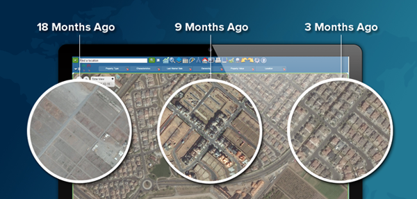
Whether you’re researching and analyzing new development areas, or looking for changes on a property over time, TimeView integration within GovClarity empowers you with powerful tools and information you simply can’t get anywhere else.
|
|
|